Areas of Focus in Mid Copeland
From Search Areas to Areas of Focus
An important part of the journey towards a Geological Disposal Facility (GDF) is identifying potentially suitable sites.
Nuclear Waste Services (NWS) is currently gathering information to understand if the current Search Areas, in Mid Copeland and South Copeland in Cumbria and Theddlethorpe, in Lincolnshire, could be suitable to host a GDF.
A Search Area is the geographical area on land made up of one or more electoral wards, where NWS is considering potential sites.
How we identified Areas of Focus in the Mid Copeland Search Area
The original Search Area was established by the Copeland GDF Working Group and taken forward by the Mid Copeland GDF Community Partnership. It included the Gosforth & Seascale and Beckermet electoral wards. The Lake District National Park was excluded from consideration.
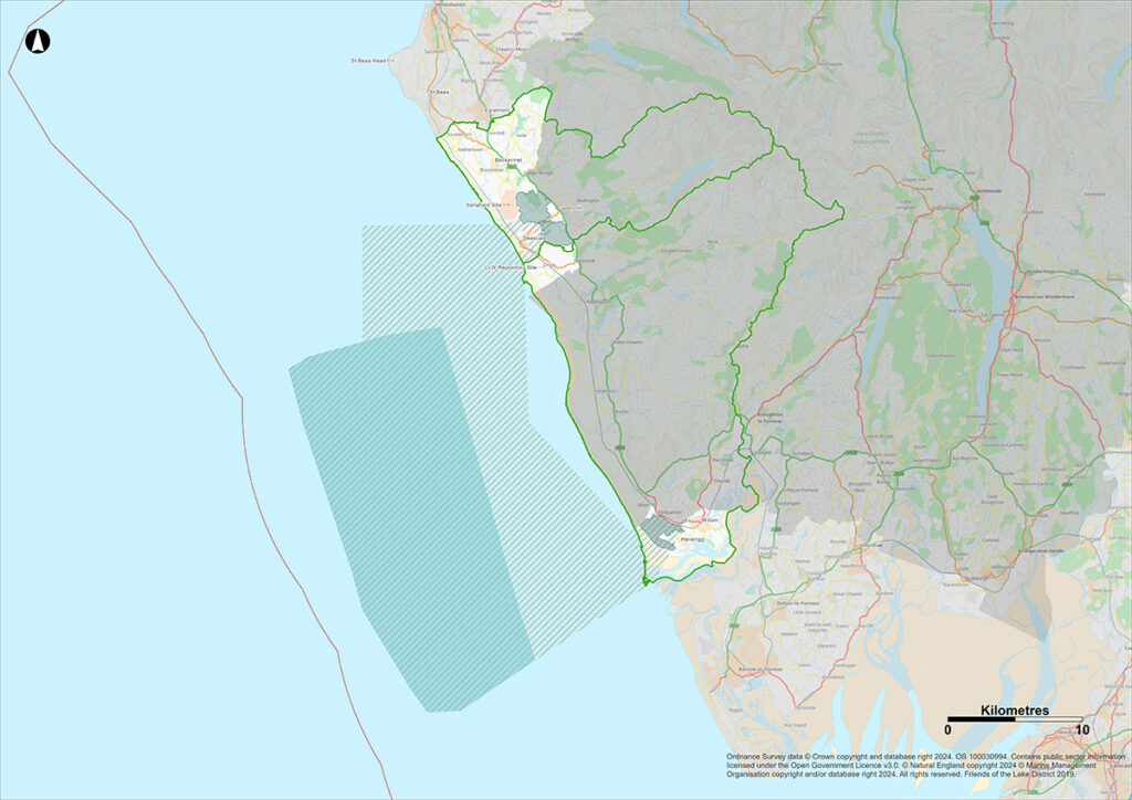
The Working Group also agreed that the focus for the Sub-surface part of a GDF – where the waste would be disposed of – would be in the deep geology beneath the inshore area up to 22km beyond the coast of the Search Area.
Following a Local Government Reorganisation in 2023, Copeland Borough Council ceased to exist, becoming part of the new Cumberland Council unitary authority, and the ward boundaries were revised. To reflect that, the Search Area boundary also changed and now covers the Gosforth electoral ward.
Our early work, which is available in the Initial Evaluation Report and subsequent Search Area Evaluation Report, confirmed the potential suitability of this Search Area and inshore area to host a GDF. These reports are available on the Community Partnership website.
NWS applied its methodology for identifying Areas of Focus to define the Sub-surface, Surface and Accessway Areas of Focus in the Mid Copeland Search Area. The methodology looks at a range of factors such as geological characteristics, protected areas, environmental constraints and community considerations.
Sub-surface Area of Focus
Alongside the National Geological Screening data, in Mid Copeland, NWS looked at legacy 2D seismic data, and 3D seismic survey data collected by NWS in August 2022. This indicates that there may be a volume of rock with suitable geological characteristics to develop a GDF, which could be accessed from a surface site. Further studies will continue to develop our understanding of this Sub-surface area as a potential host geology.
The Sub-surface Area of Focus is approximately 300km2. The full area would not be needed, yet at this early stage, looking at a larger volume of rock gives us flexibility in the design and location of the underground vaults and tunnels.
This Sub-surface Area of Focus is the same for both Mid Copeland and South Copeland Search Areas.

If you are unable to access any of the maps on this page, please attend one of our in-person events or contact the NWS helpdesk.
Surface Areas of Focus
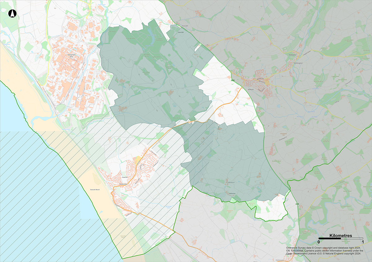
Through the application of the Areas of Focus methodology, a number of potentially suitable and less constrained areas were identified in the Mid Copeland Search Area. Further consideration of these areas that took into account NWS’ Siting Factors, as well as community and programme considerations, resulted in the identification of two Surface Areas of Focus in Mid Copeland that NWS will prioritise and consider further at this time. These are:
- Land East of Sellafield
- Land East of Seascale

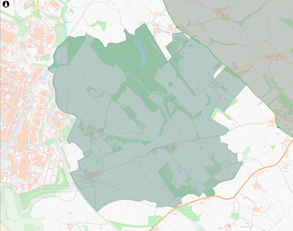
Land East of Sellafield
This Surface Area of Focus is to the east of Sellafield and between the A595 and the B5344. This land is owned by NDA Properties Limited, which is part of the Nuclear Decommissioning Authority, and is approximately 4km2. The area is adjacent to the boundary of Sellafield. A buffer of approximately 500metres has been applied from Seascale and Gosforth. Other considerations mean that Ponsonby Church, Greycroft stone circle, the ancient woodland at Calderbridge and Seascale Golf Club are not included within the Area of Focus.

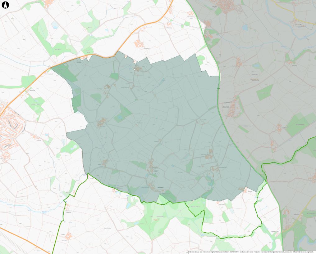
Land East of Seascale
This Surface Area of Focus is approximately 3.2 km2 of land to the south of the B5344. It is bounded by the A595 in the east and the Search Area boundary to its southern edge. A buffer of approximately 500 metres has been applied around Seascale. This constrains the shape of remaining land between the south and east of Seascale and the Search Area boundary, and is therefore excluded. An approximate 500-metre buffer has also been applied around Gosforth. The Hallsenna Moor Site of Special Scientific Interest (SSSI) is excluded from the Surface Area of Focus.

Accessway Areas of Focus
Applying the Areas of Focus methodology, we have identified potential accessways, within which the connection tunnels could be constructed, joining the Sub–surface Area of Focus to the Surface Area of Focus. This is significantly wider than will be required to allow for flexibility; it is currently estimated the final accessway will be between 250-500m wide. For the onshore part of the accessways, we have sought to avoid passing directly beneath the Sellafield site and Seascale.
Other areas NWS considered in the Search Area
Four other areas were looked at. However, at this stage, NWS is not prioritising these areas for the following reasons:
Land between Beckermet and Calderbridge
This area is approximately 4km2, and to connect this surface to the Sub-surface Area of Focus, it would require the accessways to be routed to the north of the Sellafield site to avoid tunnelling beneath Calderbridge. Compared with other options, this area is also further away from the Sub-surface Area of Focus. The combination of these circumstances would require longer accessways in comparison to other options with a likely significantly higher cost, and a longer programme during both construction and operation.
Land northeast of Haile
This area is approximately 9.6km2, and is a technically challenging area due to its hilly nature. Additionally, the distance to the Sub-surface Area of Focus would require longer accessways. To avoid accessways being located beneath Calderbridge, they would need to be routed to the north of the Sellafield site.
Land north of the River Ehen
This area is approximately 7.3km2, however it includes the settlements of Braystones, Nethertown and Coulderton. It also includes several SSSIs. These features constrain our ability to identify a single area of suitably sized land in this area.
Land north of Sellafield (including Moorside)
This area is approximately 3.5km2 to the north of the Sellafield site. It includes land within the Moorside area, which is currently subject to interest for alternative uses and as such we are not prioritising this area at this time.
Areas of Focus webinars
We held a series of events and webinars in early 2025 to talk with communities in more detail about Areas of Focus. You can watch the webinar recordings below.
Common themes discussed at events included information about a suitable site and a willing community, Test of Public Support, Site Evaluation and Property Value Protection scheme. If you have any questions, please contact us.
